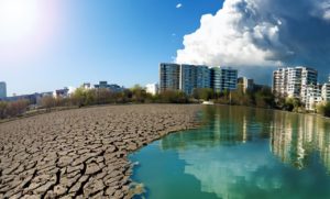
Water, the source of life, is at the heart of our existence. While its quantity on Earth has remained constant for more than 4 billion years, its distribution, on the other hand, is changing and becoming more unequal. Its sustainable management is therefore a crucial issue for the future of our planet. To better understand changes in the availability of this resource and the impacts of climate change on the water cycle, researchers and scientists are relying on an increasingly detailed approach: the complementarity between spatial data and in situ data. But why is this complementarity so beneficial? Let’s explore together the benefits of this integrated approach.
Observing the Earth from space: a global vision
Imagine being able to peer down at Earth from space, like a benevolent giant. This is what satellites allow us to do, offering us a large-scale overview both fresh and salt water resources. Thanks to them, for continental hydrology, we can observe:
- Extent of water surfaces : lakes, rivers, wetlands…
- Water level variations : floods, droughts, intermittents…
- Water quality : turbidity, presence of pollutants, etc.
- Flows
Satellites thus offer global geographic coverage, making it possible to monitor large regions, including remote or difficult to access areas. They are excellent observers of natural phenomena (floods, droughts, etc.) on a large scale, both spatial and temporal.
Return to Earth for a precise measurement
However, observation from space is not enough. Satellite observations are frequent but limited by revisit periods. Thus, satellite passages can be separated by several days.
To refine our knowledge and validate spatial data, it is essential to return to Earth. This is where the in situ data, collected by sensors and ground stations.
These highly precise field measurements allow us to:
- Measuring parameters not observable by satellite: ocean salinity, surface speed and river flow, etc.
- Capturing local and sudden variations like floods.
- Provide continuous, fine-scale monitoring, essential for resource management and decision-making in the event of an emergency.
- Calibrate and validate satellites to ensure the reliability of their data.
A marriage of data for better understanding
It is by combining spatial and in situ data that we get the most out of these two approaches. Their complementarity is a major asset for continental hydrological observation and monitoring. By combining the extensive coverage of satellites with the precision and continuity of in-situ measurements, we obtain more complete and precise vision water resources and hydrological processes. Water cycle modeling becomes more reliable and makes it possible to best predictions. Finally, new decision-making tools serving resilient water management can emerge for civil protection, agriculture, energy, tourism, etc.
vorteX-io, a major player in Cal/Val satellites
The calibration and validation of satellites (also called Cal/Val) is an essential step, which ensures the accuracy and reliability of the collected data, in order to meet the scientific and operational requirements for which they are intended.
Calibration aims to characterize and correct errors in measurements which may arise in particular from environmental conditions, the aging of the instrument or even data processing algorithms. Validation consists of assessing the accuracy and reliability of spatial data by comparing them to independent references. This is where in situ measurements come in!
You will have understood, Cal/Val is of capital importance for ensuring the quality and correct interpretation of data and thus support scientific research and the development of new products and services. vorteX-io plays an essential role in this domain. Thanks to our expertise in collecting in situ hydrological data in real time, we contribute to the Cal/Val phases of large missions or projects, in close collaboration with space agencies and experts in charge of Cal/Val.
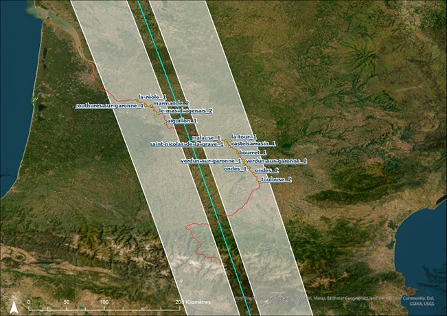
Among them are SWOT (Surface Water and Ocean Topography), St3TART (Sentinel-3 Topography mission Assessment through Reference Techniques) and St3TART Follow On.
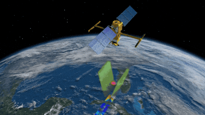
The SWOT mission
SWOT, a Franco-American mission operated jointly by the National Center for Space Studies (CNES) and the National Aeronautics and Space Administration (NASA), aims to measure the level of continental surface waters (lakes, reservoirs and rivers) and their widths, and also estimate the flow of the main rivers. It would also enable us to determine the level of the oceans and seas. 90% of the planet’s water surfaces are scrutinized by SWOT to better understand the water cycle, better control this resource and improve climate models.
In 2022, vorteX-io deployed around twenty micro-stations and conducted 4 drone campaigns with its altimeter VTX-1 on two sections of the Garonne: one between the north of Toulouse and the confluence with the Tarn, the other between Aiguillon (Lot-et-Garonne) and La Réole (Gironde). During a collaboration with the University of Caen, data was also collected on these two sections with a LiDAR on board an aircraft, then reprocessed by vorteX-io. Through these deployments, we were able to collect 300,000 water height measurements, which were compared with those measured by the SWOT satellite .
The St3TART and St3TART Follow On projects
The project St3TART is funded by the European Union and operated by the European Space Agency (ESA). It aims to define what exactly is a reference measurement, in order to validate satellite measurements on three new types of surfaces being studied: inland waters (lakes, reservoirs, rivers, estuaries, etc.), sea ice and land ice (ice caps, mountain glaciers). As an extension, the project St3TART Follow On intends to operationally produce these reference measurements, in support of the validation activities of the Sentinel-3 satellites of the Copernicus Sentinel-3 Surface Topography Mission (STM).
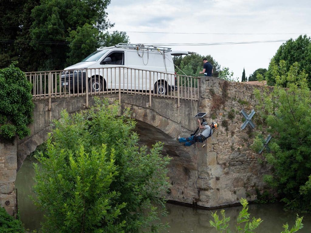
In this context and among the numerous campaigns carried out, a specific campaign was realized on the Canal du Midi , near the town of Trèbes in the south of France. This site was chosen because the Canal du Midi has a controlled water surface height and an ideal geometry (the channel is perpendicular to the Sentinel-3 track): a perfect site to evaluate the best possible performances that can be achieved by Sentinel-3! In May 2022, a vorteX-io micro-station was therefore installed on a bridge crossing the Canal du Midi, just under the passage of the satellite. The precise water heights collected by the station could be used to operationally calculate a reference measurement and compare it to Sentinel-3 data.
The comparison results obtained demonstrated the excellent performance of Sentinel-3 on this site, in accordance with the mission requirements.
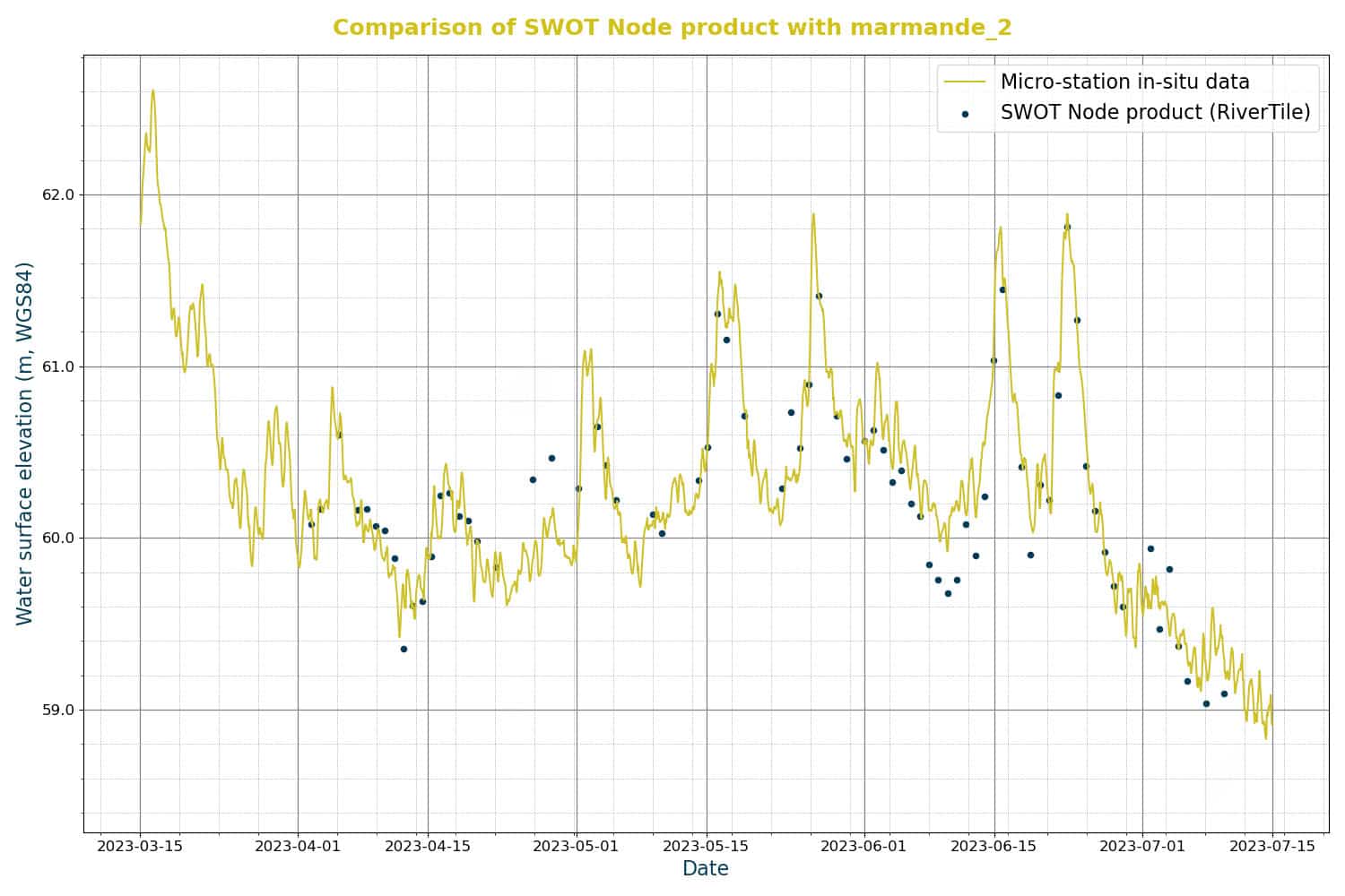
The surroundings of the French town of Marmande, located on the Garonne in Lot-et-Garonne, had been identified as another ideal site for Cal/Val project activities, thanks to the favorable orientation and location of a Sentinel-3A ground trace, and the location of a nearby Sentinel-3A crossover point. The site is also flown over by a Sentinel-6 track, which is of great interest for cross comparisons between several missions. Several in-situ instruments provide water levels along the river (Vigicrues and vorteX-io micro-stations) making it possible to refine local comparisons with satellite altimeter measurements.
In addition, on February 8, 2022, a drone equipped with the altimeter VTX-1, with an embedded LiDAR and camera, was deployed by vorteX-io to measure the height of surface water on a section of approximately 20 km along the Garonne. Overflights of the Vigicrues station in Marmande were also carried out for comparison. These measurements were used to determine the slope of the river, identify local specificities (waterfalls, ponds, etc.) and ensure accurate calibration and validation satellite altimetry over rivers.
The campaign took place during a period of low water level, which is quite common for this river. Two other campaigns were therefore carried out to estimate the slope of the river and its characteristics under different water level and flow conditions, in June 2022 and March 2023. The data collected during these flights also served for the Cal/Val of the SWOT satellite.
Hydrological observation: a crucial issue for the future
Thanks to its technical skills and advanced technologies, vorteX-io actively contributes to the advancement of space remote sensing capabilities. As water challenges increase with climate change, complementarity of spatial and in situ data is becoming more essential than ever. For water stakeholders (scientists, managers, public authorities, etc.), this integrated approach represents a powerful tool to better understand the water cycle and its evolution, predict natural disasters and adapt our resource management systems accordingly.
The vorteX-io Newsletter
Get the latest news from vorteX-io:
projects & innovations, updates of the Maelstrom® platform, in-depth articles about hydrology...